Where are they?
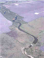
Lower coast riparian wetlands are river bottom wetlands and river-associated habitats from about the San Antonio River south to the Rio Grande. In this subhumid to semiarid region, some of these habitats are perhaps better called riparian corridors. Riparian habitats are usually transitional between uplands and wetlands.
Geology and Soils
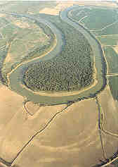
Riverine wetlands on the middle and lower coast are limited to depressions on the floodplains of rivers and major creeks. For the most part, these depressions are scour features left by the rivers: oxbows, cut-off channels, etc. Most of the depressions, but not all, have fairly clayey soils because the slack water that fills the depressions tends to deposit clay rather than sand. The depressional soils may be quite stratified, and buried surface soils that represent periods of stability with little deposition are frequently found in the profile.
The lower Rio Grande Valley is by far the largest of the riverine systems of the lower coast. This broad valley is a riverine-deltaic plain laid down by the ancestral Rio Grande, and the oxbow features in this valley are locally known as resacas.
Soil Profile of a Depressional Riverine Wetland
(Grulla Soil Series, Rio Grande Floodplain, partially filled resaca, Cameron County)
The surface soil from 0 to 7 inches is a grayish brown clay that is extremely hard when dry.
The subsoil from 7 to 30 inches is a stratified light brownish gray clay, with many large reddish brown iron coatings in the horizontal cleavage planes; very hard when dry, sticky and plastic, moderately alkaline.
A buried, dark grayish brown surface soil is found from 30 to 36 inches with few fine yellowish brown iron stains. The subsoil from 36 to 62 inches is a stratified grayish brown clay with many distinct fine yellowish brown iron coatings along interfaces of bedding planes (From the Cameron County Soil Survey)

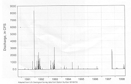
Aransas River hydrograph near Skidmore, Texas. Flood events are short duration. Only the largest peaks represent floods. No data were available for the flood stage. (GRAPH: REGINA KUBELKA)
Hydrology
Overbank flooding and runoff from the adjacent floodplain are the main sources of water for the lower coast riparian wetlands. The lower coast rivers flood much less frequently than do the rivers on the upper coast, and the rivers stay flooded for shorter periods of time. Consequently, the floodplains outside of the depressions do not stay wet long and often enough to be classified as wetlands. It is important to recognize, however, that the scarce and valuable habitats found in the riparian corridors are dependent upon the surface and subsurface hydrology of the floodplains.
Rivers such as the Aransas may flood most years, but may go several years without significant floods. The smaller rivers and creeks may flood only once every 3 to 5 years. Hydrology has been greatly modified in most rivers in this area by dams.
Vegetation
The depressional wetlands are often freshwater marshes dominated by plants like southern cattail and California bulrush in the wetter areas grading into various grasses and sedges and brush such as Drummond’s rattlebush, retama, and salt cedar. The still higher and drier riparian zone vegetation depends primarily on the groundwater level associated with the river or stream. Trees and shrubs that dominate these riparian zones include mesquite, huisache, salt cedar, hackberry/sugarberry, retama, cedar elm, Chinese tallow-tree, green ash, black and sandbar willow, and rattlebush. In the lower Rio Grande Valley, evergreen subtropical riparian woodlands can also include brush like brasil, anacua, granjeno, tepeguaje, Texas ebony, and locally, remnant groves of Texas palmetto (sabal palm trees).
Animals
Riparian habitats support many of the same animals found in riverine forested wetlands. On the lower coast, riparian woodlands and the associated water provide important fish and wildlife habitats in areas that may have little else to offer many species. Some animals found in these habitats, for example the green and ringed kingfishers, Mexican treefrog, Rio Grande chirping frog, Rio Grande river cooter, ocelot, and jaguarundi are seldom seen in other regions of Texas.
Threats
Narrow riparian corridors, because they are so limited in size to begin with, are very susceptible to disturbances such as overgrazing, channel dredging (such as is done to stabilize the international boundary), and brush control programs. Many of these habitats are now dominated by introduced or disturbance types such as salt cedar and mesquite. These two species use a lot of water and are often targeted by brush control programs related to water conservation efforts. Salt cedar and mesquite dominated riparian zones are not as desirable as a mixture of native tree and brush species, but they are better than no riparian habitat at all. They do provide habitats for birds and other animals and help stabilize stream banks and floodplain soils.
Ecological Functions and Human Values
Riparian corridors perform many of the functions mentioned for riverine forested wetlands. In semiarid climates, riparian corridors provide exceptionally valuable wildlife habitat since woodlands not associated with rivers and streams may be absent. In the lower Rio Grande Valley, many birds that are not found elsewhere in the U.S. make heavy use of riparian woodlands. Birdwatching is a prime reason so many winter Texans and others are attracted to the area. The money they spend is important to the regional economy.

