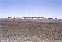
A depressional wetland on the Texas Sand Sheet. Al/ of the greener grass is wetland, with the deepest part of the wetland inundated with water. A dune complex is in the background. (DENNIS BREZINA, NRCS)
Where Are They?
The Texas Coastal Sand Sheet is a large sheet of wind blown sand and silt covering most of Kenedy and Brooks Counties, and parts of Kleberg, Starr, Hidalgo, and Willacy Counties in South Texas. Wetlands seem out of place in this desert-like landscape of dunes and blowouts, but they are a common part of the interdune depressions.
Geology and Soils
The Coastal Sand Sheet is a very young and dynamic geological feature. Wind erosion is an active process that has been shaping this landscape for at least the past 10,000 years. Many parts of the Sand Sheet are somewhat “stable” in that blowouts have not occurred for hundreds and possibly a few thousand years, but much of the sheet is covered with active dune complexes that are migrating northwestward.

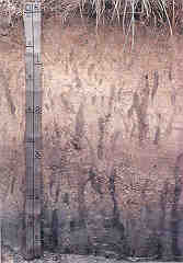
Profile of the Topo Soil Series, Kenedy Ranch. The vertical "streaks" are filled-in crawfish burrows. (JOHN JACOB)
Soil Profile of a Sand Sheet Wetland
(Topo Soil Series, Deflation Hollow of Banner Dune Complex, Kenedy County)
The surface soil to 10 inches is a slightly saline grayish brown fine sandy loam with a few iron stains on old root channels and pores. The subsoil to 50 inches is a slightly saline light gray fine sandy loam with few reddish brown iron stains on channels and pores. About 15 to 20 percent of the subsoil volume is composed of filled-in and fresh crawfish burrows. The subsoil below about 50 inches is a moderately saline greenish gray fine sandy loam with olive and greenish gray stains. The soil is moderately alkaline throughout. The soil ponds water in places for a few weeks at a time, and is saturated in the upper part for periods of several weeks through the fall and spring seasons. (from Kleberg-Kenedy Soil Survey)
Wind shapes the landscape by creating convex dunes. But for every convex dune, a concave trough or deflation depression is also created, and if these depressions are close enough to the water table, a wetland will be formed.
The soils are very sandy. A slightly more clayey layer may be found at depth. Many of the wetland soils are fairly saline because sea spray is blown inland by the onshore winds. Evaporation then concentrates salts in the soil.
Hydrology
Water is generally in short supply in this semi-arid environment, but enough of it collects often enough to support a complex wetland ecosystem. Much of the water in the depressional wetlands is from the groundwater that percolates through the sandy dune complexes.
Groundwater can be locally quite saline due to soil salinity The Sand Sheet is an effective water collector because water easily percolates through the sand and is not lost to evaporation. A clay pan or restrictive layer keeps the water from percolating too deep, and it comes to or very near the surface in some interdune swales. The clay pan may have only slightly more clay than the overlying layers, but it is sufficient to slow water movement down. Runoff may also play a role, particularly in the more stabilized areas without large dune complexes.
Vegetation
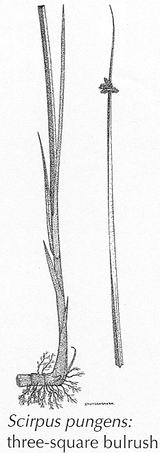
These wetlands support plant assemblages that reflect the range of salinity found in these depressions. The fresher ponds have species like California bulrush and common three-square bulrush, spikerushes, flatsedges, cattails, white-topped sedge, paspalums, Gulf cordgrass, and other water-tolerant grasses.
The more saline wetlands have more salt-tolerant species like keygrass, saltgrass, sea oxeye, Carolina wolfberry, seablight, and Gulf cordgrass.
Animals
Many of the same animals that are found in the barrier island interior wetlands are also found here. Alligators would not be expected on the Sand Sheet. The wetlands support nesting birds including fulvous and black-bellied whistling ducks, mottled duck, American coot, common moorhen, pied-billed and least grebes, and ruddy duck. Of course, in this semiarid climate, all wildlife and livestock rely on the ponds for drinking water.
Threats
As long as these wetlands remain part of a rangeland dedicated to livestock grazing, they probably will be fairly safe from development. If and when the large ranches are divided into smaller tracts of land, development could threaten these wetlands.
Ecological Functions and Human Values
Many of the fresher ponds are above the salty groundwater and help to recharge the shallow aquifers with freshwater runoff.
These wetlands are like magnets for birds and other wildlife in this semiarid climate. These ponds and wetlands provide drinking water and food for all animals including livestock.
The King and Kenedy Ranches own a large part of this region. Both ranches are incorporating nature tourism, as well as hunting, into their operations.
