The Role of Water, Wind and Time
To understand the present pattern of wetlands we must go back about 60 to 100 million years ago, when the edge of the continent was about where Dallas, Austin, and San Antonio are now. The entire region that would become the Texas coastal plain was then at the bottom of the newly opening Gulf of Mexico. Since then, the Gulf has been continuously filling in with sediment carried by rivers. These layers of gravel, sand, silt and clay may be up to 40,000 feet thick, and have extended the edge of the continent some 250 miles into the Gulf. This process of sediment deposition continues today as Texas rivers add their sediment loads (the portion that is not trapped in man-made reservoirs) to their bays or directly to the Gulf. The Texas mainland shore, coastal plain, beaches, barrier islands and peninsulas, river deltas, and bays and estuaries are all products of the processes of erosion and deposition of water-borne (alluvial) sediments.

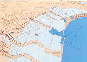
Bird's eye view of the Upper Gulf Coast of Texas. The Flat lying Beaumont and Lissie Geological Formations, laid down during past ice ages, are the location of Prairie potholes and marshes and coastal flatwood wetlands. (Redrawn from Doering, 1935)
The building of the Coastal Plain through sedimentary deposition has taken place against a backdrop of rising and falling sea levels, and what we see on the surface today is the result of the last two million years (the Ice Ages of the Pleistocene Epoch). The younger the sediments are, the easier it is to see the remains of the depositional processes. For example, many of the freshwater wetlands on the Gulf Coast today have formed in old sediment-filled channels that once formed the deltas and floodplains of ancient rivers. The channel remnants consist of oxbow lakes, cutoff channels, and, in the lower Rio Grande valley, resacas.
At the height of the last Ice Age, about 18,000 years ago, sea level was 300 to 400 feet lower than it is today and the shoreline was at least 50 miles farther out in the Gulf. During this period the coastal rivers cut deep valleys into the coastal plain sediments, which flooded and filled with sediment once the climate warmed and sea level rose as a result of the melting glaciers. Most of our fringing salt marsh wetlands have formed in the bays and estuaries that resulted from the flooding and filling of these river valleys.
Sea level rise also resulted in the formation of large sand bars along the coastline that developed into barrier islands, with Galveston Island and Padre Island among the most well known. As these islands have built seaward, a series of swales have been left behind the building sand ridges. These depressional swales are the location of prominent freshwater wetlands on these islands. Tidal fringe wetlands occur on the back or bay side of the islands.
Wind action has modified almost all of the wetland features, more so the older the landscape. Pimple mounds or small dunes, for example, are found in almost all undisturbed prairie potholes. But wind action has been the dominant landscape shaping force in the semi-arid area of the coastal plain known as the Coastal Sand Sheet. Here, coastal winds are constantly reshaping this dune-dominated landscape. Wetlands are found in the swales between the dunes, much in the same way as on the barrier islands. These wetlands often depend upon high groundwater levels.