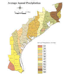
The average rainfall drops from 55 inches at Port Arthur in Jefferson County to less than 29 inches along most of the lower coast
Rainfall changes drastically from one end of the Texas Coast to the other. Average annual rainfall drops from 55 inches at Port Arthur in Jefferson County to less than 29 inches along most of the lower coast. The humid upper coast supports well-vegetated wetlands dominated by grasses and other temperate-climate plants.
In contrast, the lower coast becomes increasingly subtropical and more arid toward the Rio Grande. This climate does not support the lush wetland vegetation typical of the upper coast. The relatively sparsely vegetated sands of the lower coast are more susceptible to wind erosion, and dunes dominate many of the landscapes.
Rainfall amount also dictates how many wetlands occur in an area and where they are found. The upper coast, for example, has abundant wetlands. Almost any flat surface in the Beaumont area has slow-enough drainage to qualify as a wetland. This means that it is actually hard to find a natural area in this zone that does not have some kind of wetland characteristics. In contrast, wetlands on the lower coast are much less abundant and are confined to very distinct depressions.
Less rainfall results in less freshwater inflow supplied by rivers to the bays and estuaries. From Sabine Lake to Corpus Christi Bay, major rivers supply freshwater to the bays. The upper and lower Laguna Madre, on the other hand, has no major sources of freshwater inflow due to low rainfall and the absence of major drainages between the Nueces River and the Rio Grande. The lack of freshwater, combined with high evaporation rates and restricted Gulf inlets, normally keeps the Laguna saltier than seawater. Barren or sparsely vegetated tidal flats are typical of the wetlands fringing the Laguna, in contrast to the rather lush marshes of the upper coast estuaries.