Where Are They?
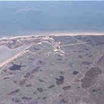
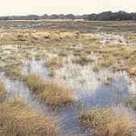
A prairie pothole complex on the Ingleside Sand in Calhoun County. (WAYNE WENTWORTH, TEXAS PARKS AND WILDLIFE)
The term “pothole” is used up and down the coast to refer rather loosely to any freshwater depression. The difference between a pothole and a marsh is mostly size -marshes occur in larger and generally less well-defined depressions than potholes. This section is limited to freshwater depressions that occur on the Lissie and Beaumont Geological Formations, and the Ingleside Sand (see below and wetland types map). “Pothole” appears to be the most common term on the coast for these depressions, but usage varies widely. In the Beaumont outcrop in Willacy County, for example, the depressions are commonly referred to as lagunas or lagunillas.
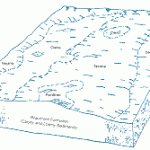
Prairie potholes and marshes occur on the prairie from just west of Beaumont to the Rio Grande. These wetlands once covered vast expanses of prairie before urbanization and agriculture destroyed most of them. Approximately 30 percent of the prairies was once wetlands. On the upper coast, potholes and marshes occur in complexes with pimple mounds (small hummocks 1-2 feet tall) and intermound flats. The pattern of mounds and wetlands is often quite intricate with abundant interfingering of uplands and wetlands. Pothole/marsh complexes in the Coastal Bend and lower coast regions have somewhat less relief than those of the upper coast.
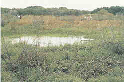
An example of a prairie pothole in Matagorda County. The small knoll is a pimple mound. (JOHN JACOB)
This complex pattern, formed thousands of years ago by ancient rivers and bayous, and modified through time by climatic (especially wind) and biotic forces, is an irreplaceable geological legacy. Once these complexes are gone, there is no replacing them. The chance confluence of the many unique factors responsible for the evolution of these wetland complexes is unique to them, and makes them a “chance-medley” we cannot repeat. We understand very little about the complex role this wetland pattern plays in coastal prairie ecology.
Because of extensive land leveling for agriculture, there are very few intact complexes left with the full range of relief, from high pimple mounds to deep potholes. Some of the best remaining complexes are in urban fringe areas. Unfortunately the same areas are now under greatest threat from development.
Geology and Soils
The most extensive prairie potholes and marshes are found on the Lissie and Beaumont Geological Formations. These potholes are remnants of the rivers that laid down the great floodplain and delta sediment deposits that make up most of the coastal plain, but the original morphology has been greatly modified by wind and other agents. The riverine nature of these scars is sometimes quite obvious, while in other places it is more obscure. The wetlands with the most obvious riverine features are found on the Beaumont Formation and range in age from 15,000 to more than 30,000 years old, while the potholes on the Lissie Formation are for the most part more than 100,000 years old. The Katy Prairie west of Houston is one of the more well known prairies on the Lissie Formation with abundant pothole wetlands.
Soil Profile of a Prairie Pothole Wetland
(Cieno Soil Series, Prairie Pothole, Jackson County)
The surface soil to a depth of about 25 inches is a dark grayish brown sandy clay loam with brownish iron coatings along old root channels and cleavage faces. The subsoil from 25 to 60 inches is a light brownish gray sandy clay loam with brown iron stains. The soil is neutral in the upper part and moderately alkaline in the lower part.
This soil is ponded with water for periods ranging from a few weeks to several months in the winter and early spring.(from the Jackson County Soil Survey)
Hydrology
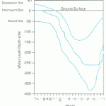
Prairie potholes and marshes are inundated by direct precipitation and by runoff from surrounding flats. Groundwater may be a factor in many potholes, particularly those on the Ingleside Sand (see below), but its role is not well understood. Hydrology in pothole complexes is very diverse, with pronounced changes occurring within just a few feet. Deeper potholes can remain saturated for more than 6 months out of the year, while adjacent pimple mounds may be nearly semi-arid for most of the year. Almost every intermediate hydrologic state will be found associated with potholes and marshes of varying depths and surrounding elevations. This hydrologic complexity translates into high habitat and biological diversity.
Hydrology changes markedly in these wetlands as one moves down the coast. Many potholes on the upper coast remain inundated for several months out of the year, with six months of wetness not uncommon in the deeper potholes. Most Coastal Bend and lower coast potholes, on the other hand, may remain saturated for only a few weeks to perhaps a month or so at a time.
 Vegetation
Potholes and marshes typically have concentric zones or belts of different habitat types. These habitats are determined by elevation and hydrology; that is, the amount and permanence of the water in each zone. The more permanent potholes may have floating and submerged plants like water lilies, pondweeds, southern naiad, and duckweed in the open water zone. The emergent zone might include cattails, bulrushes, burheads, arrowheads, and common reed. A still higher woody zone may include trees and shrubs like black willow, buttonbush, rattlebush and coffee bean, baccharis, Chinese tallow-tree (an introduced invader) on the upper and mid-coast, and retama on the mid- and lower coast.
The edges of less permanently flooded potholes and marshes might have bushy bluestem and various other grasses, spikerushes, rushes, and sedges as well as the shrubs and trees mentioned above.
Animals
Pothole/marsh wetlands and wetland/upland complexes play host to a very diverse fauna because of the great variety of habitats. Reptiles and amphibians include alligators, Gulf Coast ribbon snakes, cottonmouth moccasins, red-eared sliders, southern leopard frogs, bullfrogs, and green treefrogs. Birds include rails, cranes, all wading birds, dabbling ducks, coots, common moorhens, snipe, blackbirds and grackles, shorebirds like killdeer, marsh and sedge wrens, swamp sparrows, and most all migrating songbirds. Almost all resident animals use the ponds to drink. During drought, all wildlife concentrates near the more permanent potholes.
Threats
Agriculture was once the greatest cause of the loss of prairie potholes and marshes. Urban sprawl is probably the cause of greatest loss today. Federal wetland regulatory protection has not prevented the loss of these wetlands. The cumulative loss has been significant. On the Texas coastal plain, freshwater marshes have decreased by 29 percent since the mid 1950s, a net loss of more than 235,000 acres!
Ecological Functions and Human Values
In the spring, pothole/marsh wetlands are especially important to birds migrating across the western Gulf of Mexico. These habitats are the first source of freshwater encountered by migrants and are heavily used by songbirds, shorebirds and waterfowl and other waterbirds. These birds represent an important economic resource for coastal cities and towns. Birdwatching is a rapidly growing segment of the nature tourism industry. Coastal communities with the foresight to protect and promote these habitats will reap great long-term economic benefits. To destroy these wetlands is to “kill the goose that lays the golden egg.”
These habitats are also important to resident wildlife, particularly in the semiarid coastal regions and in times of drought. They also provide water and forage for livestock.
Special Pothole and Marsh Areas
Rice Fields
Most of the prairie potholes and marshes have been greatly modified by farming, principally for rice from Victoria to Beaumont. While rice farming has greatly modified the wetlands through land-leveling, many of the potholes remain, even if somewhat shallower than before modification. Rice is farmed only 1 year out of 3, with the other two years fallow or resting. Because of the flooding that accompanies rice cultivation and the rest or fallow period, these farmed potholes retain much of their wetland character, with a moderate soil seed bank of native wetland plants. More recent practices involving laser and water leveling, unfortunately, level the potholes completely.
Rice fields can themselves be considered a type of wetland because the fields remain flooded for significant periods. Rice fields are by far, at about 1.5 million total acres, the most abundant type of wetlands on the Texas coast. In addition to the grain, rice fields also provide other benefits to wildlife and people. The huge wintering waterfowl populations, particularly geese, enjoyed by Texas hunters and bird watchers are quite dependent on the rice farming industry. Rice fields also provide habitats for large numbers of invertebrates such as insects and crayfish. These attract herons, egrets and other wading birds, sandpipers, plovers and other shorebirds, gulls and terns, mammals, reptiles, and amphibians.
Even rice field wetlands face threats. Urban and suburban sprawl eliminates farmland of all kinds as developmental pressures drive up land values. However, the most serious threat to rice farming now seems to be the changing markets and subsidies that rice farmers have come to rely on. Much rice acreage will probably be converted to other crops that will not provide wetlands or support waterfowl. This does not bode well for a large segment of North American ducks and geese.
Ingleside Sand Freshwater Depressions
The Ingleside Sand is a remnant of an ancient barrier island or strandplain system that faced the coast during a previous period of high sea level (about 50,000 to 75,000 years ago). A strandplain is a mainland shoreline built seaward by a series of accumulated sandy beach ridges. During this period, this strandplain was somewhat analogous to the barrier islands that line the coast today, but the effects of wind and other geomorphic agents have greatly modified the original ridge and swale topography. Highs and lows are found on the Ingleside Sand, but they are much less elongate than those found on the barrier islands today.
The Ingleside Sand is especially evident along the Coastal Bend region from south of Corpus Christi Bay north to Matagorda Bay. The Encinal (Flour Bluff), Live Oak (Aransas Pass and Rockport), Blackjack and Lamar (Aransas National Wildlife Refuge), and Calhoun (Seadrift-Port O’Conner Ridge) Peninsulas are the remnants of the ancient barrier sands.
Vegetation in the Ingleside depressions is frequently similar to the vegetation found in nearby prairie potholes. The soils as a rule are much sandier, very similar to the present-day barrier island complexes, except that the Ingleside soils frequently have a layer with more clay below 30-40 inches. Groundwater may be a more important factor in these wetlands than in nearby prairie potholes of the Beaumont Geological Formation. Rainwater rapidly penetrates the sandy soils, and the claypan acts to hold the water much as a cistern would.
Lower Coast Potholes and Marshes
Lower coast pothole and marsh depressions occur in a semi-arid environment. A complex geologic unit that includes some Sand Sheet wetlands and Beaumont and Lissie-aged potholes has been lumped into one map unit, the Prairie Potholes-Lower Coast. Very little descriptive work has been done on these wetlands. The hydroperiod or time that these wetlands are wet is less than that of potholes to the north and east, but is definitely long enough for wetland vegetation to have developed in these depressions.
