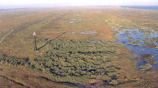
The interdune swales are particularly apparent in this aerial of Matagorda Island. The Matagorda Lighthouse is visible in the left foreground. (EARL NOTTINGHAM FOR TEXAS PARKS AND WILDLIFE)
Barrier island nontidal, freshwater wetlands are found in interdune swales (troughs between dune ridges) and on the larger, interior wind-eroded flats on the barrier islands that line the Texas coast. Tidally influenced wetlands on the bay margins of the islands are included with the Tidal Fringe wetlands.
Geology and Soils
The Gulf-fringing barrier islands are about 4,000 years old. The barrier islands formed as a result of wave action that reworked sands delivered to the Gulf by the coastal rivers and creeks. The Gulfward advance of successive beach ridges over time has resulted in a series of ridges and troughs. The dunes of the wet upper coast barriers are better vegetated and less subject to wind and water erosion than dunes on the semiarid lower coast barriers.
Soil Profile of a Barrier Island Trough
(Mustang Soil Series, Mustang Island, Nueces County)
From 0 to 6 inches the surface soil is a loose, single-grained, brownish gray fine sand, with many fine roots and few shell fragments.
The subsoil from 6 to 72 inches is a single grained, light gray fine sand, with few fine faint yellowish brown iron coatings along root channels in upper 20 inches. The soil is neutral throughout. (from the Nueces County Soil Survey)
 Hydrology
Water in the nontidal barrier island troughs is derived from a combination of runoff from the adjacent dunes and from groundwater. Water percolates through the sandy dunes very easily, and generally comes to the surface in the swales between the dunes. Many of these swales in fact rarely have ponded water on the surface, but because groundwater is found just under the surface for extended periods of time, only wetland vegetation can survive.
On the barrier islands, fresh groundwater, which is less dense (lighter) than saltwater, forms a freshwater lens, which sits atop the underlying saltwater. As the sediment layers of the coastal plain subside under their own weight, there is a relative rise in sea level and the freshwater lens rises closer to the surface. This natural subsidence is greatly magnified in regions where people have pumped massive quantities of groundwater or oil and gas. On North Padre island, within the Padre Island National Seashore, this process has caused an apparent increase in freshwater wetlands.
 Vegetation
Wetland plants are similar to those found in other freshwater marshes, but may include some brackish-water species due to elevated soil salinity in some areas. Typical species include saltmeadow cordgrass, southern cattail, bulrushes, coastal water-hyssop, coastal plain pennywort, spikerushes, flatsedges, sedges, burhead, marsh fimbry, white-topped sedge, frogfruit, coffee bean, seashore paspalum, bushy bluestem, and other grasses.
Animals
Many of the same animals found in mainland marshes are also present in the barrier island wetlands, although the diversity of species is less than on the mainland. Reptiles and amphibians include several species of frogs and toads, mud and red-eared slider turtles, Gulf Coast ribbonsnake, and alligators. Mammals include rice rats, raccoons, and feral pigs. Birds include ducks such as the mottled duck, and teals; and other water birds like coots, rails, gallinules, and grebes. Wading birds include herons, egrets and ibises. Shorebirds include sandpipers, long-billed curlew, whimbrel, willet, yellowlegs, snipe, black-bellied plover, killdeer, and dowitchers. Perching birds include the sedge wren and red-winged blackbird.
Threats
The major threat is draining and filling for development of beach houses, condos, hotels, marinas, boat docks, and their supporting infrastructure. The destruction of dune-stabilizing vegetation by human activities can cause dunes to migrate and fill wetlands.
Ecological Functions and Human Values
In times of ample rainfall, these depressions provide scarce freshwater and wetland habitats for island fauna. In dry years, when these depressions are dry, biological diversity on the barriers is depleted.
The depressional wetlands play a role in regulating the fresh groundwater levels; many acting as recharge areas when the groundwater level declines.