Where Are They?
Estuarine or tidal fringe wetlands can be vegetated (marshes) or unvegetated (mud and sand flats), and are found between the open saltwater of the bays or Gulf and the uplands of the coastal plain and barrier islands. These wetlands may occur in small strips just 10 to 20 feet wide or may be several miles wide and occupy thousands of acres. Marshes are almost always in protected areas along bay shorelines or on the bay sides of barrier islands and peninsulas. Without protection, wave energy is too great for salt marsh vegetation to get established, which is why we seldom see salt marshes on Gulf-facing beaches.
These marshes are also found on the back or bay sides of barrier islands, and also may extend inland a few miles along some of the major and minor streams that drain into the Gulf.
Geology and Soils
Except for the Chenier Plain and Laguna Madre (see below), most Texas estuarine wetlands are in river valleys that flooded when sea level rose between 18,000 and 4,000 years ago. When sea level was lower, the coastal rivers cut deep valleys into the coastal plain sediments. Most of our salt marshes have formed around the bays that resulted from the flooding and filling of these ancient river valleys. Some of these valleys have since completely filled in with sediment (for example, the bays of the Brazos, Colorado and Rio Grande). The other rivers have yet to fill in the bays into which they flow.
Estuarine wetland soils can range from clayey to sandy, but clayey soils dominate most marshes. These young soils are alluvium (carried by moving water) deposited mostly during the Holocene during the last 10,000 years.
Soil Profile of a Low Marsh Soil
(Tracosa Soil Series, near Bastrop and Christmas Bays, Brazoria County)
The surface soil to a depth of 4 inches is a dark gray mucky (organic-rich) clay that flows easily between the fingers, leaving a slight residue. It is strongly saline with a pH of 7.5. The subsoil to a depth of 62 inches is a very sticky and plastic (moldable) gray clay. It is strongly saline with a pH of about 8.0. This soil is inundated with 2-12 inches of water during the daily high tides. One or two inches of water usually remain on the surface during low tides.
(from the Soil Survey of Brazoria County)
Salt marsh soils have the most organic matter of any Texas wetland soils. They are still considered mineral soils because the organic matter is never more than 20 percent in the surface horizon, and usually much less. This is in contrast to the highly organic soils that occur in the salt marshes of the Mississippi Delta in Louisiana.
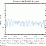
Daily and montly fluctuations in tide levels in Galveston Bay. (Re-drawn by Regina Kubelka based on material from the Texas A&M University-Corpus Christy Blucher Institute's website)
Hydrology
Salt marshes are flooded by tides and their salinity and plant communities depend upon how much freshwater is delivered to the wetlands by the rivers that flow into the bays. The high marsh is only irregularly flooded by tides, and may go for extended periods without flooding. The low marsh, on the other hand, is subject to regular flooding, at least once a day. Areas that are continuously flooded are outside the salt marsh zone, but may still have some submerged vegetation near the shore (seagrass, for example).
Terminology to describe the estuarine marshes is quite varied and far from standardized. In reality, there is both a hydrologic as well as a salinity continuum, with the frequency of flooding varying as well as whether the area is flooded with salt or fresh water. Freshwater backing up against high tides floods some fresh marshes along coastal rivers.
Gulf Coast tides do not vary much in elevation, typically only about 1 foot in vertical difference between low and high tide. We often see larger tidal ranges due to the wind, particularly if the wind is in the same direction as the tide. For example, some of our lowest tides occur at low tide in the winter with a strong northwest wind. There are many tidal flats that are exposed only at this time of year. And the highest tides often occur at high tide with a southeasterly storm.
 Vegetation
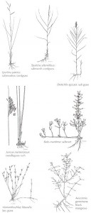
Cordgrasses of the Spartina genus are the most prominent salt marsh vegetation. Flooding frequency (how often) and duration (for how long) (see Hydrology) and the salinity level are the most important variables that control the kinds of plants that occur in the salt marsh. In the high marsh, saltmeadow cordgrass might be the most common grass, whereas in the lower marsh, saltmarsh cordgrass is more common. Additional vegetation includes saltgrass, saltmarsh bulrush, and needlegrass rush among other.
Animals
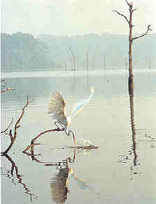
Typical animals include herons, egrets, ibises and other wading birds that feed on the fish, shrimp, crabs and other invertebrates found in the wetlands. Shorebirds and waterfowl are abundant. The American alligator feeds on fish, snakes, turtles, frogs, muskrats, nutria, swamp rabbits, rats and anything else it can catch. Bobcats, coyotes, raccoons, skunks, mink and river otters also hunt in the marshes.
Threats
Estuarine wetlands are threatened by land subsidence and relative sea level rise that causes marshes to drown and be converted to open water. Subsidence and dredged channels and canals allow saltwater to intrude inland into fresher areas causing vegetation changes. There is direct marsh loss to dredging, filling, and spoil deposition caused by various kinds of development. Dredging activities cause increased water turbidity that threatens seagrasses. Dams on the rivers that supply freshwater and sediment to the bays have altered the fresh water inflow processes that maintain the estuaries. Runoff pollution from urban and agricultural sources, and oil and chemical spills damage vegetation and animals. Since then mid-1950s, the area of salt and brackish marshes on the Texas coast has decreased by more than eight percent; a net loss of more than 31,000 acres.
Along the entire coast, unvegetated tidal mud/sand flats have decreased in area by about 13 percent since the mid-1950s; a net loss of more than 30,000 acres. Much of the loss was due to the construction of dredge-spoil compartments along the Intracoastal Waterway and other ship channels.
Even in south Texas, black mangrove is subject to periodic severe dieback caused by freezing temperatures. Another, more permanent threat is development in the intertidal zone for resorts, marinas, beach houses and boat docks, roads and causeways, canals and ship channels, and so on.
The Laguna Madre is being filled in with wind-blown sand from Padre Island. The sandy flats that separate the upper and lower Laguna is an area called the Land-Cut; a name that relates to the excavation of the Gulf Intracoastal Waterway. This region of the Laguna filled with wind-blown sand perhaps 150 years ago.
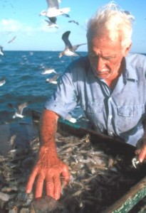
Shrimp are just one species of fish and shellfish that are dependent on estuarine habitats for at least part of their life cycle. (JAMEY TIDWELL)
Ecological Functions and Human Values
Many economically important finfish and shellfish use estuarine wetlands during at least part of their life cycles. The wetland habitats are used for spawning, as nursery areas, and for foraging. Shrimp, crabs and oysters all depend upon estuarine habitats. Predatory fish like red and black drum, seatrout, and southern flounder are supported by estuarine invertebrates and forage fishes like bay anchovy, striped mullet, bay silversides, killifishes and gobies.
Seagrass beds provide feeding habitat for game fish, migratory waterfowl (especially redhead ducks), and sea turtles. They serve as nursery areas for fish, crabs and shrimp.
These fish and wildlife habitats help support economically important commercial and recreational fishing, hunting and birdwatching industries.
Estuarine wetlands perform other functions such as protecting shorelines from erosion and dampening storm surges.
Unique Estuarine Regions
Chenier Plain
The Chenier Plain is a unique salt marsh area on the extreme eastern edge of the Texas Gulf Coast, and is part of a much larger chenier plain in western Louisiana. A chenier plain is a series of sandy or shelly ridges or “cheniers,” many more than 10 feet high, separated by clayey or silty marsh deposits. The distance from chenier to chenier may be as much as 1 or 2 miles or more. “Chenier” comes from the French word for oak, which is the dominant tree on the ridges. The Texas Chenier Plain started to form about 3,000 years ago when the mouth of the Mississippi River shifted to the west bringing an increase in sediment to southwestern Louisiana and extreme southeast Texas. These sediments built marshes out into the Gulf. During periods of low sediment input, wave action reworked the Gulf-facing sediments into ridges or cheniers, until the next pulse of sediment built marsh further out into the Gulf again, resulting in the characteristic series of ridges.
The mouth of the Mississippi has shifted repeatedly during the last 3,000 years causing alternating slow beach deposition and rapid marsh building into the Gulf. In this way, the once broad bay of the Sabine and Neches Rivers was cut off from the Gulf by the deposition of the Chenier Plain wetlands. Wetlands in the low areas between the beach ridges are estuarine salt and brackish marshes connected by tidal channels to Sabine Pass.
Laguna Madre
The Laguna Madre is the very salty lagoon that supports the estuarine wetlands of the lower coast. The lower coast has extensive estuarine wetlands, but they bear little resemblance to the lush emergent marshes of the humid upper coast. Saltwort, glassworts, saltgrass, keygrass, seapurslane, sea-oxeye, and a few other plants dominate the limited emergent salt marshes fringing the Laguna. Saltmarsh cordgrass is only a minor component of lower coast salt marshes.
Fringing the Laguna Madre are broad, nearly unvegetated wind-tidal salt flats. These sandy flats are not regularly flooded by tides. They are only occasionally flooded when strong winds push shallow water from the Laguna onto the low flats. The cycle of irregular flooding and drying causes salt to build up on the surface of the flats. These salt flats are inhospitable to most vascular plants, but are often covered by vast mats of blue-green algae. These habitats may look barren, but they support rich invertebrate populations that, in turn, attract large numbers of shorebirds and wading birds.
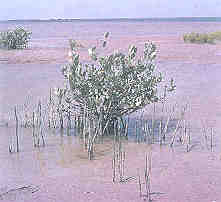
Black mangrove, a tropical species, forms shrub wetlands in the intertidal fringe of the Laguna Madre. Four species of tropical mangroves occur around the Gulf of Mexico, but only black mangrove is found north of the Rio Grande. Mangrove wetlands can be seen along the causeway between Port Isabel and South Padre Island, and fringing South Bay, just south of the Brownsville Ship Channel near Brazos Santiago Pass. Mangroves also occur near Harbor Island in Aransas Bay near Aransas Pass.Mangrove wetlands support many invertebrates such as snails, crabs, mussels and amphipods. On high tides, shrimp and fish enter the mangal to feed. These animals attract wading birds like the reddish egret, other egrets and herons, ibises, night-herons, roseate spoonbills, and wood storks. Almost all the shorebirds, gulls and terns found on the lower coast also use the mangals, as do the predators mentioned above.
Seagrass beds are much more abundant in the upper and lower Laguna Madre than in other Texas bays. This is because the waters of the Laguna are shallow and clear, allowing good light penetration to the grass beds. The waters are clear because the Laguna bottoms are sandy and generally lack clayey sediments. There are no rivers feeding clayey sediments into the Laguna and the Rio Grande flows directly into the Gulf.
